What surveying you can do within a Farmer Cluster depends on many things – what you’re interested in, how much time you have, how big an area you want to cover, whether you want outside help and how long-term you are thinking. In its most basic form, surveying is identifying a given species or habitat, location, time and date, and keeping a record of it. This will be of use to someone, somewhere. But to provide real value to science and conservation, and to gauge how well the Farmer Cluster is performing, there are more structured ways to survey and go about monitoring the improvements that you are bringing about.
Why is it important to survey?
We think it is important to survey your wildlife or other objectives you have set for your Farmer Cluster because:
- It gives you the confidence that what you are doing to improve things is working.
- It sets benchmarks of achievement within and between Clusters and with Rural and National datasets.
- It allows Treasury to be reassured that the money spent is being spent well and objectives are being achieved.
Creating a baseline
If one day you would like to be able to review and visualise the progress you have made in your project, you’ll need to kick off your monitoring effort by establishing a baseline for your chosen species/habitats. This baseline could be one or two years’ worth of data, to which you compare the results of future years. For example, ‘the baseline for a yellowhammer population in 2017 was 45 singing males’. If your baseline year happens to be an extreme or abnormal one, like 2018, it may be best to extend the baseline to two years and take averages of the data collected.
You will gain much more insight and explain many more variances by surveying your chosen species every year, rather than every few years. However, with limited manpower you may only be able to survey on an alternating basis – one species one year, and another the next, for example. The main rule of thumb is, survey as often and as widely across the cluster as you possibly can and keep consistent in your chosen method.
Choosing a survey method
The UK has a range of dedicated National surveys, designed to collect data about specific wildlife groups: for example, the Big Farmland Bird Count, Glow Worm Survey, Wider Countryside Butterfly Survey and BeeWalk. If your target species is covered by a National survey, it is best if you adopt their methodology because it is tried and tested and allows you to compare your data with other data sets. However, some National surveys issue you a random survey area, meaning you cannot survey where you want to. Or, they are demanding in terms of time and resources, meaning you may not be able to meet the required number of visits or sites. If it is not possible to meet the exact methodology, you can adapt it to your situation, and this monitoring menu gives ideas on how to do this. If your data cannot be incorporated into the National survey scheme it’s not the end of the world – you can use it to make valuable comparisons for yourselves (and keep your data confidentially within the group if you so wish).
Who will do this monitoring?
Depending on the wildlife groups/objectives you choose you can use different methods to do the monitoring – starting with yourself and family, including farm staff, local volunteers in the surrounding area, right up to choosing professionals. Costs will increase as you go up this hierarchy from nothing (yourselves) to paying petrol money or making a donation to a local wildlife group, up to paying a fee for professional help.
Here are examples of people that may get involved with surveys:
- Facilitator
- Landowner
- Landowner’s family and friends
- Farm/estate staff and residents
- Gamekeepers
- Farm/estate advisors or agents
- Local villagers
- Schools
- Village clubs e.g. WI, Rotary, tea/coffee mornings
- Local wildlife enthusiasts and volunteers
- Professional ecologists (£)
- Researchers (linked to specific projects)
Facilitators and farmers can do the majority of the community outreach to find willing surveyors. Over time, as the group establishes, local networks and connections emerge and you’ll begin to find people who can give up time to help you.
To find volunteers, why not upload your group description to Nature Volunteers, a new website launched by Bournemouth University to help match people to local projects
Surveying on a large scale
For Farmer Clusters to demonstrate their value, surveys need to be adapted and designed to collect data to detect improvements over time at the wider landscape level.
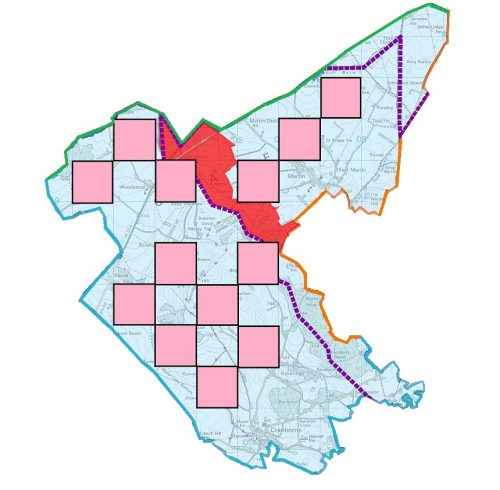
Surveying a very large contiguous area is challenging. We suggest an alternating 1km grid Ordnance Survey ‘chequerboard’ approach, because this ensures that data are collected systematically and evenly at a landscape scale. Not all squares are ideal for survey e.g. multiple landowners complicating access, low percentage of farmland, main road intersecting etc. Simply apply this grid over your farmer cluster and work out which squares are eligible for survey. Then, you can apply your chosen method e.g. a BeeWalk, to all these squares, to give a systematic spread of survey routes.
A map of the systematic survey square approach on Martin Down Farmer Cluster. Each pink square is 1km x 1km.
Blue = Martin Down Cluster, with survey squares shown in pink
Red = Martin Down National Nature Reserve
Orange line = border with Allenford Farmer Cluster
Green line = border with Chalke Valley Farmer Cluster
Purple dotted line = county boundaries

