Lead: Geoffrey Probert Geoffrey.Probert@bevills.co.uk
Facilitator: Fiona Wells fiona@rural-advice.co.uk
Group members: 26
Length of agreement: self administered, perspective 25 years+
Area of group (hectares): c8,000
Location:
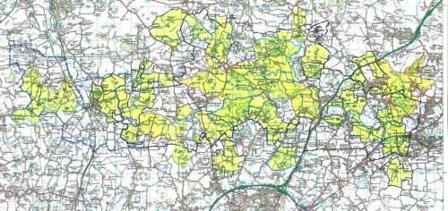
The cluster farms ‘Constable Country’ on the Essex Suffolk border. The footprint of the cluster (deliberately) matches the Dedham Vale AONB immortalised in the paintings of John Constable and Thomas Gainsborough.
The Cluster area follows the River Stour upstream from the mouth of the estuary at the eastern end to Bures at its western extent. This is an agricultural landscape with a mix of arable, pasture and woodland. The Assington Brook and Rivers Box and Brett flow south into the Stour.
It is a famously beautiful piece of East Anglia.
Priorities:
To combine and integrate productive agriculture with landscape scale enhancement of biodiversity and resource protection.
Throughout the project area there are cross cutting themes that the group will work together on e.g. inter farm corridors, renovation of ponds, a mosaic of scrub, the East Anglian mink eradication programme (to help water vole & kingfishers), expansion of the range of native black poplar & other projects.
Designated Sites:
- Stour and Orwell Estuaries Ramsar Site & Special Protection Area (SPA) (part);
- Cattawade Marshes Site of Special Scientific Interest (SSSI) (part);
- Arger Fen SSSI;
- Arger Fen & Tiger Hill Local Nature Reserves;
- Seven Scheduled Monuments;
- One Registered Park;
- A numerous and rich diversity of Listed Buildings contribute to the sense of place for this AONB.
Biodiversity:
Priority Habitats: Natural England’s Priority Habitat Inventory for this area includes ancient semi natural woodland, plantation woodland on ancient sites and secondary woodlands; wood pasture and parkland (across six or more un-registered parks); floodplain grazing marsh; hedgerows and traditional orchards.
The cluster has additionally identified veteran trees, farmland ponds and arable field margins amongst their priorities.
Priority Species: lapwing; barn owl; grey partridge; swift; yellow wagtail; hedgehog; water vole; dormouse, pollinating insects; dung beetles and black poplar.
Water Quality: under the Water Framework Directive, the Environment Agency & Natural England list the Stour & Brett river catchments as ‘at risk’ drinking water safeguard zones. The River Box catchment is identified by EA and NE as a high priority area for addressing surface water pesticides, phosphates and sediment issues. The Facilitator will make recommendations on a farm by farm basis in relation to these priorities.
Soil Health: the Cluster recognises the role of soil health in productivity for both agriculture and biodiversity. The Facilitator will make recommendations on a farm by farm basis to enhance the sustainability and resilience of their soils.
Historic Environment: ·The Cluster area encompasses numerous designated sites included on the National Heritage List for England, including above and below ground archaeological sites; and a rich heritage of listed buildings such as the National Trust ‘s Flatford Mill and many Suffolk ‘Wool’ Churches; also a number of important historic houses. Water meadows, parkland & traditional farm buildings are integral to the AONB landscape. There are many additional sites of archaeological importance recorded on the county Historic Environment Record.
Landscape: The cluster area lies within the wider South Suffolk and North Essex Clayland National Character Area (NCA no. 86). Key characteristic of this NCA are scattered woodlands on valley slopes and high ground, many connected by historically important, sinuous hedgerows that also frame narrow lanes; hedgerow trees are important features. Valley meadows and grassland on poorer, free draining soils occur throughout the cluster area contributing to a rich field pattern. Cricket bat willows (salix alba caerulea) – which were first recorded in Suffolk in 1780 – are an important crop throughout the river valleys.

